| About | |
| Creationism Research | |
| Biblical Research | |
| Bamboo Research | |
| Oak Research | |
| Contact |
|
|
||||||||||||||||||
CHAPTER 3THE STUDY AREA & SURVEY METHOLOLOGY3.1.1 The Study AreaThe area chosen for the fieldwork was in the Wirral peninsula, which lies between the estuaries of the Dee and the Mersey (Map 1). This area was chosen for the following reasons: Firstly it contained a “reasonable population” of hedgerow oak trees, a reasonable population being one of sufficient size to give a good sample accuracy (Hetherington, 1975). Secondly it was uniform in topography, climate, geology and soil type. Thirdly, as transport was a limiting factor, it was within cycling distance of my home. 3.1.2 ClimateTables 2a and 2b show the mean monthly temperatures and rainfall recorded at Bidston Observatory which is located in the north of the Wirral. Table 2a: Mean Monthly Temperature For Bidston Observatory (Hewitt, 1922).
Table 2b: Rainfall Information For Bidston Observatory (from Hewitt, 1922).
3.1.3 Geology and soilsThe solid geology of the Wirral peninsula consists of sandstones and marls belonging to the Triassic formation. The only exception to this is a small area of Carboniferous sandstone and shales near Neston on the side of the Dee estuary. Table 3 : Sub-divisions of The Triassic Sandstone Series
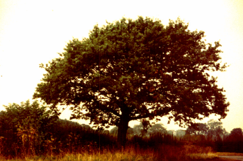
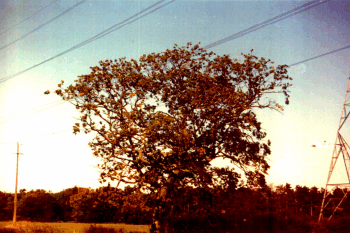
All the sub-divisions of the Triassic sandstone series (Table 3) are found on the surface or in exposed cuttings in some part of the Wirral, but for the most part they are hidden under superficial glacial ueposits (Hewitt, 1922). Due to the action of the glaciers the Wirral is extremely flat, its hignest point being about 200 metres above sea level. Gould et al (1982) surnmarises the physical and climatic factors on the Wirral as follows: “Within Merseyside, an area with an equable climate ana unspectacular topography, the principal determinant of land capability is soil type.” Medium to heavy clay soils (Map 2) dominate the farmland. Much of the land is under permanent grassland, with dairy farming the principal enterprise. Despite some limitations in the flexibility of cropping, the inherent soil fertility is high and aue to a comparatively long growing season it supports highly productive grassland. Most of the glacial till is classed as agricultural grade 3, but one area of blown sand in North Wirral is grade 2 (Map 3). 3.2.1 Survey MethodologyUsing a 1:10 000 scale Ordnance Survey map of the farmland area shown in map 1, six 200 metre wide transects were marked out using the East-West grid lines (see Map 4). This would give a 20 percent sample which would be sufficient to facilitate further analysis. As the transects crossed private farmland, belonging to the Lever-Hulme Estate, the Estate manager was contacted and his permission sought in order to carry out the survey. After receiving the necessary permission, every tenant farmer on the estate was contacted by letter. Most did not reply, but it was assumed from this that they had no objection. An initial survey of roadside trees was carried out in order to identify any problems involved in sampling, and to determine if there was any difference in their condition compared with other hedgerow trees. As the roadside trees were all on public property they were easy to get to and no permission had to be sought in order to measure them. The trees measured in the roadside tree survey were not included in the transepts. 3.2.2 Fieldwork MethodologyA booking form was drawn up from which sufficient information could be derived to find the trees’ total and timber volumes. A number of descriptive categories were included to determine the potential timber quality. A ‘young’ tree was simply defined as any tree with a dbh less than 20 cm. A tree was ‘over-mature’ if it had: a timber height of 0 m, due to disease or decay; miscoloured or sparse foliage (note the luxuriant green of the tree in Photograph 1 compared with the pale sparse foliage of that in Photograph 2); very large decayed or dead. limbs or slime fluxes exuding from the bole. ‘Dead’ trees also included trees that were only just alive, often referred to as ‘ruins’. Any tree which did not fit into any of the above categories was recorded as being ‘mature’. Photograph 1: Tree With Healthy Crown
Photograph 2: Oak Tree With Poor Crown
To count as a sample tree, an oak had to lie within the 200 m transect or the road boundary, have no obstruction around it (such as a dense hedge or heavy growth of ivy) which would prevent the dbh being measured, and be either free-standing or part of a group of less than 0.1 hectare in area. 3.3.1 Fieldwork DetailThe fieldwork was carried out during September 1986. On arriving at a sample tree, the total height and the timber height were measured or estimated, at first using a hipsometer, but after a few days the total height could be estimated to the nearest metre by eye. The timber height was estimated to the nearest 0.5 m. The dbh was then measured using a girth-diameter tape. Standing back from the tree, a visual assessment was made as described in section 3.2.2. 3.3.2 Method Of Timber Volume Calculation This was derived using Huber’s formula:
The timber height (L) was defined as the length of clean bole (to 7 cm top diameter) which would be suitable for sale as a sawlog. This was usually up to the lowest major limb. Trees with obvious stem rot, stem damage and twisted or deformed butts were given a timber height of zero (Forestry Commission, 1984). An average taper for open grown oak trees of 1:150 was assumed and the theoretical value for gm calculated. In all cases there was no significant difference between this theoretical value for gm and the trees basal area. So simply by converting dbh to Basal Area and multiplying this value by the timber height, the approximate timber volume was found. 3.3.3 Method Of Total Volume CalculationThe calculation of the estimated total volume of the tree was slightly more complicated. Cannell (1984) suggests the following approximations for trees with heavy crowns:
This provides a reasonable estimate of the average total tree volume, out is unreliable for the total volume of individual trees. 3.3.4 Analysis of ResultsThe data collected from the 515 trees sampled was fed into the Universities DEC-2020 computer and analysed using the MINITAB statistics package. Output of the raw data files are contained in Tables 18, 19, 20, 21, 22 & 23. © 1987 Robert I. BradshawGo on to Chapter 4 |
||||||||||||||||||